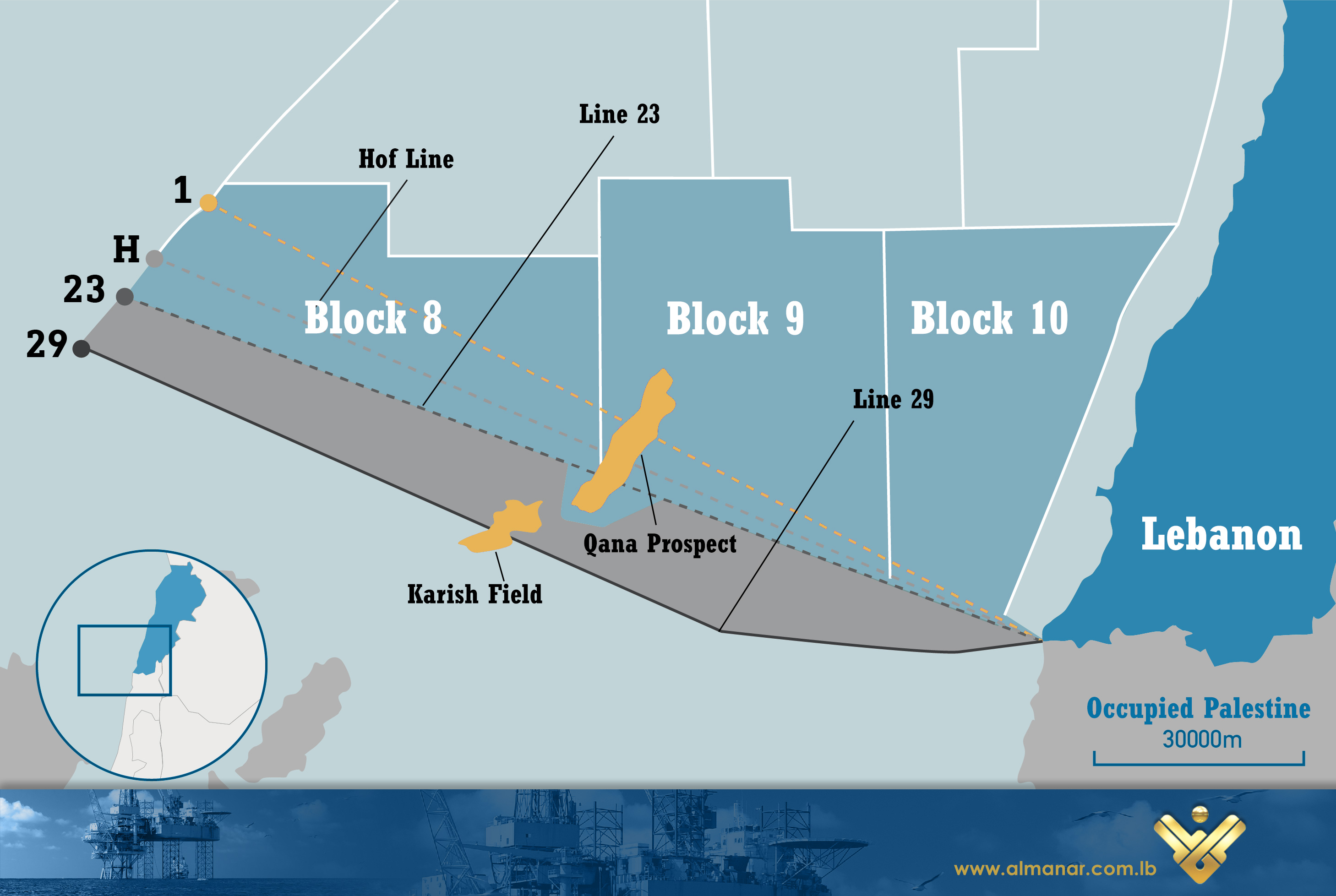
We often hear about ‘Line 1’, ‘Line 23’, ‘Hof Line’ and ‘Line 29’. Here a general review* prepared by Al-Manar on the lines which Lebanon and the Zionist entity are negotiating on in the indirect maritime borders talks brokered by the United States.
How It Started
Following the Israeli withdrawal from south Lebanon in 2000, the United Nations experts drew the so-called Blue Line separating the Lebanese territories and the occupied Palestinian territories. Lebanon dealt with it as a withdrawal line, as it was agreed that this was not a formal border demarcation.
 Unlike Lebanon, the Zionist entity dealt with the Blue Line as a final border demarcation, knowing that Beirut has announced its reservation regarding at least 13 border points in the area.
This disagreement has created a conflict with the Zionist entity at that time regarding the first point in the land, or the point of equidistance, and this is the core dispute between the two sides when it comes to the demarcation of their maritime borders.
In 2002, Lebanon tasked the National Oceanography Centre Southampton (NOCS) along with the UK Hydrographic Office to prepare a study that would help the country know its borders in the territorial waters*. The study was not completed then because of “lack of information and maps.”
Later in 2006, the Lebanese government directly asked the UK Hydrographic Office to prepare another study about the issue.
‘Line 1’
In 2007, then embattled Lebanese Prime Minister Fuad Siniora tasked a director in the Ministry of Works and Transport, Abdul Hafiz Al-Qayssi, with holding talks with Cyprus on demarcating maritime borders with Lebanon.
At that time, many officials and experts cast doubt on Siniora’s move, challenging that the Lebanese Government was “controversial” and “nonconventional” after the resignation of Shiite ministers over disputes that followed 2006 July War.
During Al-Qayssi’s visit to Nicosia (in 2007), he and the Cypriot side agreed on a point of equidistance called at that time ‘Point 1’. In an unofficial agreement, the two sides agreed that the ‘Point1’ represents Lebanon’s most distant point, with a note which says that this point is not final and that the negotiating process was still pending.
The agreement was not ratified by the Lebanese Government and has not entered into force.
‘Line 23’
In 2008, Al-Qayssi was questioned by the Lebanese Parliament over the agreement with Cyprus, and the study by the UK Hydrographic Office was contested by several Lebanese experts who argued that it was inaccurate information and maps. A Lebanese joint committee was formed by then national unity government in a bid to prepare a detailed report on Lebanon’s exclusive economic zone (EEZ)*. The committee issued its report in April 2009, editing Lebanon’s southern point of equidistance to another which was named ‘Point 23’.
In 2010, Cyprus and the Zionist entity have signed an accord on demarcating their maritime borders to facilitate offshore gas exploration. The agreement was based on Cyprus’ maritime boundaries with Lebanon, with ‘Point 1’ assigned as the most distant point.
In 2011, Decree No. 6433, an official document on the delineation of the boundaries of the exclusive economic zone of Lebanon, was issued. The decree was sent to the United Nations and annexed by a list of the geographical coordinates of points.
The first article of the decree mentioned that Lebanon’s exclusive economic zone is situated beyond the territorial sea and includes the whole of the contiguous zone, extending towards the high seas, measured from the baseline in accordance with the provisions of the 1982 United Nations Convention on the Law of the Sea.
‘Hof Line’
 The 2010 agreement between Cyprus and the Zionist entity created a dispute with Lebanon which denounced the deal as an attack on its sovereign rights over that zone. The occupation regime, however, deposited its coordinates to the United Nations in July 2011.
Following the dispute over the 860 square kilometers between Lebanon and the Zionist entity the US dispatched in 2012 its envoy Fredrec Hof, who proposed to then-Prime Minister Mikati the attribution of 55 percent of the disputed area to Lebanon and 45 percent to the occupation regime. However, both sides refused the proposal of the so-called ‘Hof Line’.
The dispute over ‘Line 1’ and ‘Line 23’ gathered momentum in late 2017, when Lebanon signed a gas exploration and production agreement with a consortium comprising the French company Total, the Italian Eni and the Russian Novatek for gas blocks 4 and 9.
In October 2020, Lebanon and the Zionist entity started indirect talks on demarcation of their maritime borders. Five rounds took place between October 2020 and May 2021. US Energy Envoy Amos Hochstein mediate the talks.
However, many in Lebanon have been casting doubt on the nature of Hochstein’s ‘mediating role’, arguing that he is an Israeli-born official who served in the occupation army between 1992 and 1995 and took part in the Israeli aggression on Lebanon in 1993.
‘Line 29’
According to studies conducted by the Lebanese army and endorsed by the UK Hydrographic Office in 2021, Lebanon could claim a further 1,430 square kilometers. The new delimitation, Line 29, would break into the Karish field.
Proponents of ‘Line 29’ argue that it was delineated based on solid legal and cartographic grounds by ignoring a rocky outcrop, Tekhelet Islet, lying one kilometer off the northern Palestinian coast, as a point of equidistance to form the boundary.
There have been calls in Lebanon to amend the 2011 Decree No. 6433, which indicates the coordinates of Line 23 as the country’s southern maritime border.
Hezbollah and Lebanese State
Hezbollah has repeatedly said that the only side who is responsible for the negotiations is the Lebanese State, with Secretary General Sayyed Hasan Nasrallah stressing that Resistance is behind the State and voicing readiness to defend the country’s wealth by all means. Another issue Hezbollah warns about is the US and Israeli veto on Lebanon to hire international companies in order to extract gas and oil off its shore. In this regard, Sayyed Nasrallah was very clear: “If Lebanon was prevented to extract gas and oil, then ‘Israel’ will be prevented to do so.”
* This overview has been prepared based on reports conducted by Al-Akhbar’s Dawoud Rammal, Middle East Eye’s Dario Sabbagh and Washington Institute’s Simon Henderson
* Territorial Waters: Countries can claim up to 12 nautical miles from their coasts as territorial waters. (One nautical mile is approximately 1.15 miles.)
* EEZ: The UN Convention on the Law of the Sea allows countries to claim a further 200 nautical miles as an exclusive economic zone (EEZ) for fishing and mineral rights.
Source: Al-Manar English Website

