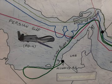
Iran’s Foreign Minister Mohammad Javad Zarif has tweeted a map with detailed coordinates that shows a US spy drone shot down two days ago was within the Islamic Republic’s territorial waters.
 “For more visual detail on the path, location, and point of impact of the US military drone Iran shot down on Thursday, and of the waters over which it was flying, see these maps and coordinates,” Mohammad Javad Zarif wrote on his Twitter account on Saturday.
“There can be no doubt about where the vessel was when it was brought down,” Zarif wrote.
The map also showed two yellow squares on the flight path of the doomed drone which indicated Iranian radio warnings sent to the aircraft.
“One last visual: Red dot is the impact point of the trespassing drone against the border of Iran; and the border of the United States,” Zarif stressed.
The Islamic Revolution Guards Corps (IRGC) shot down a US surveillance drone Thursday in the Strait of Hormuz after it did not heed four warning signals, even as the force spared a second spy plane carrying 35 passengers which accompanied the downed aircraft.
Hours after the incident, the US military confirmed that one of its drones had been shot, claiming that the incident took place in international airspace.
Source: Press TV


